GEOGATE
GEOGATE – GISAS
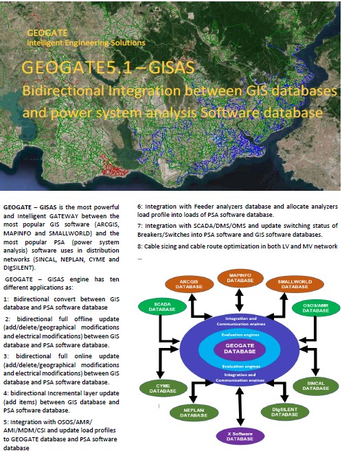
GEOGATE – GISAS is the most powerful and Intelligent GATEWAY between the most popular GIS software (ARCGIS, MAPINFO and SMALLWORLD) and the most popular PSA (power system analysis) software uses in distribution networks (SINCAL, NEPLAN, CYME and DIgSILENT).
GEOGATE – GISAS Convert from GIS Software to Analysis software.
Engine has ten different applications as:
- Bidirectional convert between GIS database and PSA software database.
- bidirectional full offline update (add/delete/geographical modifications and electrical modifications) between GIS database and PSA software database.
- bidirectional full online update (add/delete/geographical modifications and electrical modifications) between GIS database and PSA software database.
- bidirectional Incremental layer update (add items) between GIS database and PSA software database.
- Integration with OSOS/AMR/ AMI/MDM/CSI and update load profiles to GEOGATE database and PSA software database.
- Integration with Feeder analyzers database and allocate analyzers load profile into loads of PSA software database.
- Integration with SCADA/DMS/OMS and update switching/Breakers status into PSA software database and GIS software database.
- Cable sizing and cable route optimization in both LV and MV network.
- Overhead line conductor sizing and optimization in both LV and MV network.
- finding optimized geographical and electrical location of connecting MV or LV load to network including optimized transformer sizing and cable routes/Overhead line routes based on google map, Heris map and ...
GEOGATE is an intelligent and ready to be customized solution that needs minimum time to be adopted / established based on your GIS tables attribute, Layers, fields, and data format.
The time that is required to customize GEOGATE based on your company GIS data structure/format/attributes and deliver GEOGATE, full functional and with all the features, could be as fast as 45 working days.
GEOGATE is a smart solution can do automatic mapping for your GIS layers/tables and generate online up-to- date and accurate distribution network models, ready for planning and operational studies executed with your PSA software.
GEOGATE-GISAS equipped with an advanced, supper fast and intelligent search algorithm/engine named “GEOGATE-AutoCorrect”
GIS-AutoCorrect:
GIS-AutoCorrect is an enhanced data validation and search engine that can validate electrical data and geographical coordinate data in GIS and GEOGATE database and has following capabilities:

- Validating GIS data from electrical point of view based on electrical data (as cable cross section, equipment nominal voltages, operating voltages, electrical loops, equipment rating, relay, and CT sizes, and ….)
- Automatically distinguishing , reporting and/or fixing dis-connectivity and mis-connectivity in GIS database and PSA Software database
- Validating voltages of sections connecting to a node and report or/and fix mal-connectivity’s in GIS Software database and PSA Software database
- Finding MV/LV transformers with no protections and automatically creating and sizing busbars, switches, breakers, CT’s, Fuses, in both PSA software database and GIS Software database for transformers has no protection/switching equipment (uncompleted GIS data)
- Tracing from source/feeders to downstream and validating equipment rating, electrical data, operating voltage, and nominal voltage
- Tracing from source/feeders to downstream and validating feeder id and connectivity of all equipment
- Distingushing Island area and evaluating the best possible connection point to energized grid.
- Automatically creating relays in PSA software for breakers with no relay/CT in GIS database and calculating primary pickup current of relays and CT ratio
- Unifying split busbars of GIS while building electrical network in PSA software
- Creating loads for MV/LV transformers based on transformer rating or based on OSOS/AMI/AMR data
- Split Lines and cables at branch poles
- Connect end of lines/cables to intermediate point of another lines/cables with the same voltage level (default distance 30 cm, but it is but it can be customized and changed by user)
- Find disconnected lines/cables in one side and in both sides, report and connect them to closest valid energized line/cables, busbars, transformers, etc...
- Find disconnected busbars in one side and in both sides, report and connect them to closest busbars transformers, etc…
- Distinguish, report, and remove duplicates equipment’s in names and duplicates equipment’s in geographical location in GIS database and fix it while transfer data to PSA software database
- Split line/cables at switch/breaker/transformer/fuse points
- Separating duplicated transformers at the same location with different id’s and connecting them to the network
- Distinguish, report and open electrical loops
- Distinguish, report and open geographical loops
- Split busbars at switches/breakers//fuse points
- Checking Integration status of an equipment in GIS
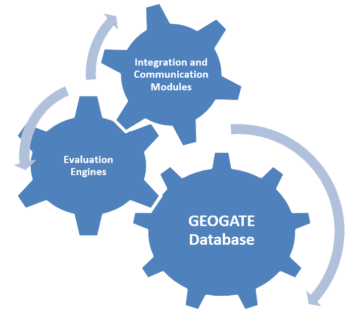
GEOGATE Database and interface with GIS software database and power system analysis software database:
-PSA(Power system analysis) software database/file format could be access (.mdb), SQL, Oracle, XML, sxst, CIM, pfd, dz, nepprj and dgs/ndt -GIS software database can be shape file(*.shp), personal geodatabase(*.mdb), gdb geodatabase(*.gdb), Mapinfo Interchange format file(*.mif), Mapinfo tab file(*.tab), dBASE DBF(*.dbf) , Delimited ASCI(*.txt), comma delimited CSV(*.csv) SQL and Oracle.-GEOGATE database can be access (*.mdb, *.accdb), oracle and SQL and it can be installed as server, using SQL or oracle database or as client, using access database.
GEOGATE has following features that can be added to basic package based on client request:
- Automatically creating HV/MV substation in both GIS and PSA software based on one access or excel input data that simply specifies locations of substations, number of busbars, number of incoming and number of outgoings, type of busbars and substations
- Creating Single line diagram in both GIS and PSA software based on geographical data of substations
- Creating Single line diagram in both GIS and PSA software based on substations voltage levels and location of sources/feeders
- Fast update from GIS to PSA software when GIS data are in gdb, mdb, oracle , SQL, MIF, csv and txt format and GIS software is ARCGIS or MAPINFO
- Export results and reports to excel, access, word and pdf
- Intranet/ web application of GEOGATE to show results of validations and reports in web/ Intranet
- Web report of electrical data: results of PSA software analysis can be shown in web/intranet based on client request and customizable design
- Electrical calculation results as load flow, voltage drop, short circuit calculations, load allocations, relay coordination’s etc.… (voltages, powers and currents and devices settings) can be shown and updated in GIS as a new layer and in web as a customizable report
- Preparing full report of integration process and GIS data validation and corrections for all equipment’s in web
- Web service feature to extract data or results from GEOGATE database or update data in GEOGATE database, customizable and available for all the GEOGATE fields and features
- Capability to access to GEOGATE features and database by web/intranet interface
Example of a successful integration:

GEOGATE-5.0Rev.1.4 GISAS-TR brochure
|

GEOGATE-5.1Rev.1.0 GISAS-EN brochure
|
